Going deep: New ground motion model more accurately simulates earthquakes, explosions

Lawrence Livermore National Laboratory (LLNL) scientists have created a new adjoint waveform tomography model that more accurately simulates earthquake and explosion ground motions. The paper, published in the Journal of Geophysical Research: Solid Earth, was selected for an Editor's Highlight.
Seismic tomography is a method to estimate the inaccessible three-dimensional (3D) seismic material properties of the Earth, specifically the speeds of compressional and shear waves related composition and temperature variations. It provides images of 3D structures that relate to plate tectonic processes as well as models to better represent seismic wave propagation through Earth's complex structure.
Unlike typical seismic tomography models, this model uses fully three-dimensional wave propagation simulations to compute the sensitivity of observed seismograms to Earth structure, enabling more accurate simulations and better estimates of seismic source properties.
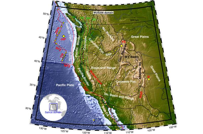
In the new research, scientists created a new model of the 3D seismic structure for the upper 400 km of the Earth in the western United States using adjoint waveform tomography (AWT). The model is produced by a computationally intensive waveform inversion process that updates the sub-surface model to improve the match to observed seismograms. In order to triangulate features in the model, AWT also is data-intensive, requiring many seismograms crossing the target region.
The team—made up of scientists from LLNL's Geophysical Monitoring Program (GMP) and researchers from Mondaic, a small incubator start-up company from the Swiss Federal Institute of Technology—used more than 60,000 HPC simulations on LLNL's Lassen supercomputer to run 256 model iterations for 72 earthquakes to fit nearly 100,000 seismograms.
"While other models of the western U.S. exist, this model is unique in that it is based on many more inversion iterations than previous models and provides much better fits to recorded seismograms," said LLNL scientist Artie Rodgers, lead author of the paper. "It also can provide more accurate estimates of seismic source characteristics by removing distortion due to unknown 3D Earth structure in previous models."
Researchers found that seismic structure is made up of 3D variations in compressional and shear seismic wave speeds and density, and horizontally and vertically polarized waves have different speeds.
While many seismic tomography studies focus on imaging of sub-surface structure, the primary motivation in the new work was the development of a 3D model for improved waveform fits of periods of 20 to 120 seconds after an Earth motion.
"We produced a more detailed 3D structure of the crust and upper mantle for the purposes of improving predictive capabilities of 3D waveform simulations for applications such as source characterization and/or long-period earthquake ground motion simulations," Rodgers said. "Waveform fits are remarkably better with our final model compared to previous models of the same region."
Nuclear explosion monitoring methods can benefit from 3D models that can accurately simulate short-period waveforms (20 s), which are strongly impacted by crustal and upper mantle structure. Similarly, earthquake ground motion hazard and risk studies require simulations of much shorter-period waveforms (less than 5–10 s) than found in the new model. However, Rodgers said the large-scale structure must first fit the longer period data before drilling down to the shorter period waves. Work to resolve finer-scale structure is underway.
This new method enables LLNL to exploit more seismic waveform information to support national and international monitoring of nuclear tests. UC Berkeley graduate student Claire Doody and LLNL scientists Andrea Chiang and Nathan Simmons also contributed to the research.
More information: A. Rodgers et al, WUS256: An Adjoint Waveform Tomography Model of the Crust and Upper Mantle of the Western United States for Improved Waveform Simulations, Journal of Geophysical Research: Solid Earth (2022). DOI: 10.1029/2022JB024549
Journal information: Journal of Geophysical Research: Solid Earth
Provided by Lawrence Livermore National Laboratory


